19530630 01 Flood Horw LU: Unterschied zwischen den Versionen
Zur Navigation springen
Zur Suche springen
Kaiko (Diskussion | Beiträge) (Die Seite wurde neu angelegt: „== Quick Facts == {| class="wikitable" style="border: 2px solid darkgrey;" |- ! scope="row" style="text-align:left" width="200pt" | Type of Event | width="800…“) |
Kaiko (Diskussion | Beiträge) |
||
| Zeile 41: | Zeile 41: | ||
==Ereignis== | ==Ereignis== | ||
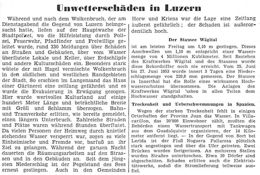
[[File:19530630 01 Flood Horw LU_Bild Die Tat.jpg| | [[File:19530630 01 Flood Horw LU_Bild Die Tat.jpg|866px]]<br/><br/> | ||
[[File:19530630 01 Flood Horw LU_text1.jpg|866px]]<br/> | [[File:19530630 01 Flood Horw LU_text1.jpg|866px]]<br/> | ||
Quelle: Die Tat 2. Juli 1953<br/><br/> | Quelle: Die Tat 2. Juli 1953<br/><br/> | ||
Version vom 15. März 2020, 11:01 Uhr
Quick Facts
| Type of Event | Flash Flood |
|---|---|
| Verification State | QC1 |
| ESWD | Not reported |
| Location | Horw (LU), Luzern (LU) |
| Time / Duration | 16.00 - 18.00 Uhr local time |
| Date | 30.06.1953 |
| Magnitude / Dimension | >50mm of rain in 1 hour |
| Damage | Flooded streets and maedows |
| Fatalities | - |
| Injuries | - |
| Report Source | Historical reports |
| Remarks | - Pegel Vierwaldstättersee 434.80 m.ü.M. - |
Ereignis

Quelle: Freiburger Nachrichten, 2. Juli 1953
Messwerte
Luzern Regierungsgebäude: 83mm
Bürgenstock: 58mm
Betroffene Gewässer
-
Medienlinks
© MeteoSchweiz ANNALEN der SCHWEIZERISCHEN METEOROLOGISCHEN ZENTRAL-ANSTALT 1953
Interna
| SSWD Main Editor | Kaiko | Last Edit | 15.03.2020 | Last Review | - | Documentation State | Ready for Review |
|---|

